Forecast & Warning
The NOAA National Weather Service supports two U.S Tsunami Warning Centers dedicated to providing tsunami forecasts and warnings for vulnerable domestic and international coastlines. Skilled personnel monitor earthquake activity and issue messages based on initial seismic information, specifically earthquake location, depth, and magnitude, frequently before tsunami waves are detected. Each center has designated areas of responsibility for preparing and issuing tsunami messages:
1. The National Tsunami Warning Center in Palmer, Alaska, provides warning and forecasts for
coastlines along the continental United States, Alaska, and Canada.
2. The Pacific Tsunami Warning Center in Honolulu, Hawaii, serves the U.S. Pacific and Caribbean
territories, and the British Virgin Islands and is the primary international forecast center for
the Intergovernmental Oceanographic Commission of the United Nations Educational,
Scientific, and Cultural Organization's warning systems for the Pacific and Caribbean:
the Pacific Tsunami Warning and Mitigation System and the Tsunami and
Other Coastal Hazards Warning System for the Caribbean and Adjacent Regions
As tsunami waves propagate, or move across the ocean, networks of shallow and deep-water instruments along coastlines and throughout the world oceans report changes in sea level that either confirm or eliminate the existence of tsunami waves. When a tsunami is detected and confirmed, data from the seismic and sea-level networks are fed into NOAA’s numerical tsunami forecast models. Messages issued subsequent to the first are iteratively refined with output from these models in combination with additional seismic information, sea-level measurements, and historical tsunami information as information continues to be reported. The overarching goal is to notify and keep emergency managers, the public, and other partners updated on the potential tsunami impact along coastlines within respective jurisdictions in order to maximize reaction time.
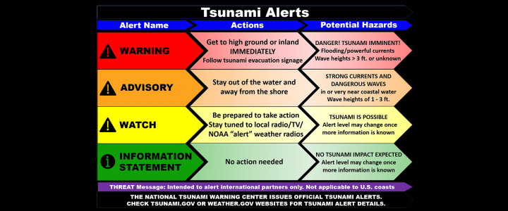
The U.S. Tsunami Warning Centers issue tsunami messages (above image) to notify emergency managers, the public, and other partners about the potential for a tsunami following a possible tsunami-generating event. To provide messages as early as possible, the warning centers use preset criteria based on preliminary earthquake information, before a tsunami is detected, to help them decide when and for where to issue tsunami messages and what alert(s) to include. Subsequent messages and alerts are based on impact estimation resulting from additional seismic analysis, water-level measurements, tsunami forecast model results, and historical tsunami information.
Detailed information on the U.S. National Weather Service tsunami warning centers and activities is available at: https://www.tsunami.gov/


